
In this topic i'll mention a part of my book titled: " Shifaa elmaradh fi tahkik qiblat ahl el-ardh "; that means : « Cure of disease in earth-people qibla achievement » ; a fiqh and geodesic research in arabic.
ذكر بعض الأحاديث من كتاب تاريخ صنعاء
1-عبد الرزاق قال حماد بن سعيد بن رمانة قال أخبرني بعض أشياخي أن رسول الله صلى الله عليه و سلم أمر وبر بن يوحنس الأنصاري حين أرسله الى صنعاء واليا عليها فقال –"ادعهم إلى الإيمان،فإن أطاعوا لك به فاشرع الصلاة، فإذا أطاعوا لك بها ،فمر ببناء المسجد لهم في بستان باذان من الصخرة التي في أصل غمدان واستقبل به الجبل الذي يقال له ضين". فلما ألقى إليهم وبر هذه الصفة من النبي صلى الله عليه و سلم في المسجد، و قدوم أبان بن سعيد، فأس المسجد على هذه الصفة في بستان باذان في أصل الصخرة و استقبل به ضين.
2-قال أبو محمد حدثني يوسف بن عبد الرحيم بن حميد بن سليمان بن شروس قال سمعت ابن رومي يقول أن رجلا من أهل صنعاء قال سمعت أباك عبد الرحيم يذكر أن أبان بن سعيد هو الذي أمر ببناء مسجد صنعاء ما بين غمدان إلى الحجرة الململة فوجدت الحجرفي زقاق ابن ثمامة فكبر الناس.
3-قال الكشوري ذكر بعض المشائخ أن مسجد ضهر بني سنة سنة يعني أول سنة التأريخ و مسجد صنعاء سنة ست من التأريخ و ذكر لي أن جدته أول من أسلم بصنعاء بمنزل في المصرع مصرع الجزارين.
4-قال أبو الحسن سليمان بن وهب عن النعمان بن بزرج في حديثه قال كان يعلى من أصحاب أبان و يروى أن وبر بن يحنس كان أيضا من أصحاب أبان و روي أن المهاجر لما تخلف عن غزوة تبوك فوجد عليه رسول الله صلى الله عليه و سلم وكان اسمه الوليد، و إنما سماه رسول الله صلى الله عليه و سلم المهاجر فرأت أخته زوجة رسول الله صلى الله عليه و سلم و هي أم سلمة النبي طيب النفس فأرسلت إلى أخيها المهاجر أن ادخل على رسول الله صلى الله عليه و سلم و اعتذر اليه، ففعل فرضي عنه، واستعمله على صنعاء فسار حتى بلغ أدنى اليمن ثم أخبر أن الأسود العنسي الكذاب قد غلب على صنعاء فرجع إلى المدينة فلم يزل الأسود مقيما بصنعاء حتى قتله قيس بن مكشوح المرادي و داذويه بن هرمز و فيروذ الديلمي، فيروى أن رسول الله صلى الله عليه و سلم بعث وبر بن يحنس الكلبي الى صنعاء فنزل في كنيسة صنعاء عند بابها و قد مات باذان الفارسي و استخلف داذويه على صنعاء و كان ابن أخيه فلما قدم وبر بن يحنس أنزله داذويه عند باب صنعاء الذي يلي قبليها قال و لما قتل قيس و داذويه و فيروز الأسود الكذاب بعثوا برأسه إلى رسول الله صلى الله عليه و سلم فكتب إلى وبر يبني حائط باذان مسجدا و يجعله من الصخرة إلى موضع جدره، و يستقبل بقبلته ضينا و هو جبل مرمل، فهذا ما روى. فمنهم من قال بناه المهاجر و منهم من قال بناه فروة و الله أعلم بذلك و كل هؤلاء دخلوا صنعاء في ما روي في أيام رسول الله صلى الله عليه و سلم.
ذكر حديث من معجم الطبراني الأوسط (طبعة الحرمين)
* الحديث831 حدثنا أحمد بن يحي الحلواني قال نا إبراهيم بن محمد بن عرعرة قال نا عبد الملك بن عبد الرحمن الذماري عن النعمان بن بزرج قال حدثني ابن رمانة قال قال وبر بن عيسى الخزاعي (مكتوب في هامش الكتاب كذا في الموضعين بالأصل و صوابه "يحنس" كما في الثقات 42913 و الاستيعاب 2716 و الاصابة 9110) "قال لي رسول الله إذا بنيت مسجد صنعاء فاجعله عن يمين جبل يقال له ضين".
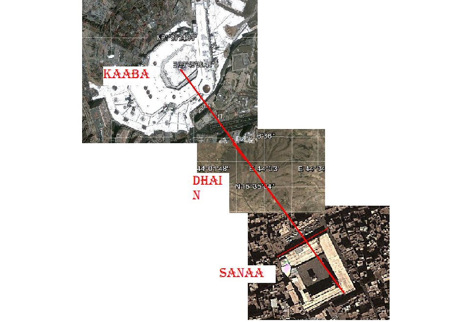
The meaning of the colored phrases is: Mohamed PBUH ordered Ouabr bin Yohannes Elkhozaai to build the mosque of Sana'a in the garden of Badhan in the rock of the origin of Ghomdan palace and to direct its qiblah to the mountain of Dhain.
So, to perform this i did this work using google earth and the spherical calculations, i found this miraculous concord between the reality and mohamed's hadith.
If we prolong the line from the Sana'a mosque passing per Dhain mountain it will reach the Kaaba in its center.
In the sunnah there are no hadiths precising in detail the method to direct mosques to the qibla except those of sana'a.
The people of yemen consider this as an origin to define the qibla of all their mosques.
I am sure that there is no one in the age of Mohammed PBUH except him can define a direction from distant cities like this accuracy.
So this was a real miracle.
Sana'a mosque and its qibla direction
Started by abdelouahed, Feb 25 2013 12:10 PM
6 replies to this topic
#3

Posted 26 February 2013 - 10:05 PM
I know that the mosque of sana'a was enlarged and rebuilt in the past , so i think that the builders perhaps they changed the original orientation of the northwest and other walls slightly to other directions and i don't say that this was intentionally but for certain constrains.
Don't look to the surface of the mosque but look to the orders of the prophet and the method to direct the qiblah by three marks: the place of the mosque, the mountain of Dhain and Kaaba.
I defy every specialist in maths and geodesy to prove that: the direction of qibla don't face kaaba in its place of today.
The image seems like that is slightly inclined to the north, i consider this a human error from the builders because the hadiths is clear that the qibla from that precise place is towards Dhain, i didn't visit the mosque and i didn't see it from the interior, and how the muslims direct them selves to the real qiblah; perhaps they incline slightly to the left of the mosque to face the real qiblah by inclining the carpets or something like this, and if i go there i'll direct my self to the real qiblah which the prophet PBUH showed to us.
You said that nabataeans direct them selves by stars , what about terrestrial marks? Also i defy every one in the world to prove that a person in that age determined a location of a city distant by 815 km as this accuracy by a straight line.
After research in isnad and matn i think that the hadiths are all true. What about your opinion?
#4
Posted 26 February 2013 - 10:32 PM
Thank you for your quote. Abu al-Qasim Sulaiman ibn Ahmad ibn Al-Tabarani was born sometime in 260 AH and lived until 360 AH, so his writings are from around 300 years after the construction of the mosque. By that time the Petra Qibla had been forgotten, and people were looking for reasons why they mosque might have had a different Qibla. Look at the photo below. I am sorry this photo is so large. I don't know how to reduce it in size on this discussion board.
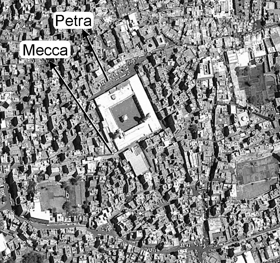
From my observation, both personally from the ground, and using satellite photos, the Qibla of this mosque points closer to Petra than to Mecca. Tabrani was simply recording stories of how the locals defended the mosque direction.
As for accuracy, I believe that several hundred years before Muhammad, the Nabataean merchants could accurately determine their location, and their destination across the desert using the stars. I take a whole chapter to outline this in my book.
#6
Posted 27 February 2013 - 02:37 PM
Latitude was found using qiyās and isba’ while longatude used taf’īla. Pliny the Elder, during Roman times observed the Arabs using this sytem. This was hundreds of years before the founding of Islam.
If they know the latitude and longitude, how did they do to define the direction of cities and location from a specific place?
I ask here about the math formula linking between latitude and longitude to obtain the azimuth of a place?
Also, can you mention a real case that was done by them to define a place direction using terrestrial marks like what the prophet PBUH did?
You said" By that time the Petra Qibla had been forgotten, and people were looking for reasons why they mosque might have had a different Qibla", i understand from this that Sana'a people knew that mecca is behind Dhain by a straight line; no no no, is this a rational reasoning? It's totally against the science and the history; if that was the case i will be sure that they were very developed than 20th century people, i guess that they had theodolites, sextants, stopwatch: Else; was this done by coincidence?
The weighting is: this description is superhuman and miraculous.
#7
Posted 07 July 2013 - 09:35 PM
If they know the latitude and longitude, how did they do to define the direction of cities and location from a specific place?
I ask here about the math formula linking between latitude and longitude to obtain the azimuth of a place?
Also, can you mention a real case that was done by them to define a place direction using terrestrial marks like what the prophet PBUH did?
You said" By that time the Petra Qibla had been forgotten, and people were looking for reasons why they mosque might have had a different Qibla", i understand from this that Sana'a people knew that mecca is behind Dhain by a straight line; no no no, is this a rational reasoning? It's totally against the science and the history; if that was the case i will be sure that they were very developed than 20th century people, i guess that they had theodolites, sextants, stopwatch: Else; was this done by coincidence?
The weighting is: this description is superhuman and miraculous.
As I mentioned in the first section, I will post an article on the science of qiyās in the download section.


